
Explains how real-time GPS and geo-time targeting enable dynamic taxi-top ads, improving relevance, engagement, and ROI.
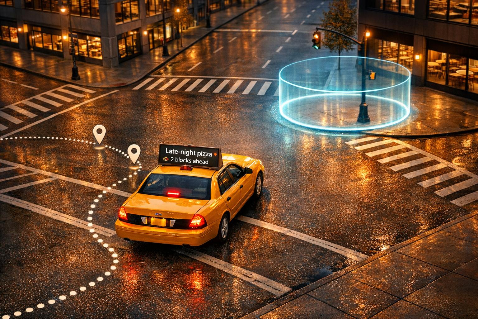
GPS technology transforms taxi advertising into a dynamic, location-based marketing tool. Ads displayed on taxi tops now adapt in real time to location, time of day, and even weather. This strategy, called geo-time targeting, ensures ads reach the right audience at the right moment. Here's how it works:
This approach combines precise targeting, time-sensitive triggers, and real-time analytics to deliver measurable impact. Whether promoting a local coffee shop or a global brand, GPS-powered taxi advertising is reshaping how marketers connect with audiences.
GPS-enabled advertising leverages satellite technology to track a taxi's exact location and deliver ads tailored to that specific area. Taxis equipped with GPS devices constantly record their latitude and longitude coordinates. Cities are divided into small geographic units, often called "hexes", which cover approximately a 0.1-mile radius. This approach allows advertisers to pinpoint specific neighborhoods or commercial zones, ensuring ads are displayed to the right audience as taxis move through various parts of the city. The ability to use this precise location data is what makes real-time ad targeting possible.
When a taxi enters a specific geographic zone, its GPS sensor instantly sends the vehicle's coordinates to a supply-side platform (SSP). This process happens in milliseconds, initiating a real-time bidding request that informs advertisers of the taxi's exact location. The system can also trigger ads based on context. For instance, it might display an ad for iced coffee on a hot day, umbrellas during rainy weather, or dinner deals when passing through restaurant districts.
Another key feature is negative geofencing, which uses GPS data to block ads in sensitive areas like schools, religious institutions, or medical facilities.
Roey Franco, SVP of Product at Firefly, explains how these systems operate:
"We deliver to [Reveal Mobile], in real time, our lat-longs for every single vehicle, and they crunch the numbers and estimate the impression multiplier."
- Roey Franco, SVP of Product, Firefly
These advanced tracking capabilities form the backbone of highly targeted, location-specific ad campaigns.
Some brands have already demonstrated the power of location-based advertising. For example, Burger King’s "Whopper Detour" campaign used geofencing through Braze and Radar to target 14,000 McDonald’s locations across the U.S. When app users came within 600 feet of a McDonald’s, they received a push notification offering a Whopper for just one cent - if they ordered through the Burger King app. This clever campaign resulted in 3.2 million new app downloads, a 53.7% increase in monthly active users, and an impressive 37:1 return on investment (ROI).
Similarly, Canva utilized GPS data to deliver personalized messages in 20 languages across 190 countries. By tailoring content to match users’ locations and preferences, Canva saw a 33% boost in email open rates and a 2.5% increase in overall engagement.
To set up GPS-driven taxi advertising, several hardware components need to work together seamlessly. At the heart of the system is a GPS receiver, which connects to satellites to determine the vehicle’s precise location. This works alongside display units, such as external LED screens and in-vehicle touch displays, to show targeted ads.
A 4G/LTE modem ensures real-time syncing of ad content and performance data with a cloud-based management platform. Power for the system is typically drawn from the vehicle’s OBD II port (requiring 9–36V DC power) or directly from the fuse box using an in-line fuse rated between 5 and 10 amps. To protect the taxi’s battery, smart power controllers with low-voltage cut-offs are often used.
An on-board media player stores cached ad content locally, ensuring ads continue to display even if the cellular signal drops. For better visibility and energy efficiency, optional light sensors can adjust screen brightness automatically, reaching up to 4,500 nits in daylight conditions.
| Component | Primary Function | Connection Type |
|---|---|---|
| GPS Receiver | Determines vehicle location via satellite | Internal or External Antenna |
| 4G/LTE Modem | Syncs ads and performance data with the cloud | Cellular Network |
| LED/LCD Screen | Displays targeted ads | DC Power / Controller Cable |
| OBD II Interface | Supplies power and vehicle diagnostics | Vehicle OBD II Port |
| Light Sensor | Adjusts screen brightness for visibility and safety | Built into display |
After installation, calibrating the GPS system is a crucial step to ensure accurate ad delivery.
Accurate calibration is key to ensuring ads are displayed at the right place and time. Properly calibrated systems prevent ads from appearing too early when approaching a target zone or in unintended areas.
Before launching campaigns, seal all mounting points with silicone and use waterproof heat-shrink tubing on wire connections to guard against water damage and corrosion. Opt for hardware with an IP66 weatherproof rating to handle exposure to rain, wind, and dust. For the best results, professional installation at a specialized depot is recommended. This ensures the system is securely mounted and properly integrated with the taxi’s electrical setup.
To maintain performance, inspect LED panels weekly and clean their lenses to keep brightness levels optimal. Additionally, ensure compliance with local regulations regarding brightness limits, motion restrictions, and permits before activating the system.

5-Step GPS Geo-Time Targeting Setup Process for Taxi Advertising
Start by pinpointing high-traffic areas where your audience is most likely to be. These could be business districts, shopping malls, or transportation hubs - places where your message will have the greatest impact. Many platforms now use the H3 hexagonal geospatial indexing system, which divides cities into small zones about 0.1 miles wide, allowing for precise targeting.
You can define these zones using various mapping methods. For example:
When setting up zones, make sure each is large enough that a vehicle takes at least 15 seconds to cross it - this aligns with standard GPS refresh intervals. Additionally, you can exclude certain areas, like schools or medical facilities, using negative geofencing. Adding demographic overlays helps refine your zones further, ensuring they align with your audience. Once your zones are set, you can focus on scheduling ads during the times they’ll have the most impact.
Timing is everything. Schedule your ads to run during hours when your audience is most engaged. For instance:
Use your platform’s condition-based logic to link specific ads to triggers like GPS coordinates and time. For example, an ad will only play if a vehicle enters a geofenced area during the designated time window. Set the GPS refresh interval to around 15 seconds to ensure accurate detection when vehicles move in or out of zones. To further optimize your strategy, consider incorporating real-time environmental data.
Enhance your targeting by integrating real-time data using APIs or custom scripts that output coordinates in JSON format. This allows for dynamic ad adjustments based on current conditions. For example:
Third-party measurement tools can also provide impression multipliers, adjusting counts based on factors like traffic, weather, or seasonal trends. To avoid issues with lost GPS signals, set a 5-minute timeout that reverts to the last known location if the signal drops.
Before launching your campaign, simulate vehicle routes through your targeted zones. This ensures that ads trigger correctly as vehicles move through the zones during the scheduled times. Double-check that your geofences are the right size - vehicles should remain within them longer than the GPS refresh interval to avoid missed triggers.
Test scenarios like signal loss to confirm that timeout settings and negative geofences work as planned. This step helps prevent wasted ad spend and ensures your ads don’t appear in unintended areas. Proper testing guarantees your GPS-triggered ads function smoothly across all zones and conditions.
Once your campaign is live, use GPS data logs and analytics dashboards to monitor performance. Track metrics like impressions by location and time to see which zones and time slots deliver the best results. For instance, some platforms calculate impression multipliers based on factors like time of day and audience density in specific areas.
Analyzing real-time metrics - such as geographic reach, impression counts, and time-based trends - helps you fine-tune your strategy. Expand successful zones, adjust time windows, or reallocate budgets to maximize results. For example, in a cosmetics campaign, precise location targeting led to an 85% boost in purchase intent and a 43% increase in brand awareness. These insights allow you to continually improve your geo-time targeting for even better outcomes.
Using GPS data, advertisers can zero in on high-impact areas like shopping malls, business hubs, and transit centers. Real-time tracking allows ads to appear only when taxis enter specific locations. For instance, a coffee shop can promote morning deals to commuters downtown, while a restaurant can advertise lunch specials in busy dining areas during midday.
But it doesn’t stop at location tracking. GPS data also uncovers travel patterns and routes, helping brands anticipate where people are headed. This means businesses can target professionals in financial districts during weekday commutes or families near parks on weekends. By narrowing in on specific demographics, brands avoid wasting ad dollars and ensure every impression has value. This precision doesn’t just save money - it also boosts engagement with the right audience.
Ads that connect with a viewer's immediate environment naturally grab more attention than generic campaigns. For example, promoting umbrellas during a rainy day or highlighting dinner specials near entertainment venues feels relevant and timely. It’s no surprise that 59% of people take action after seeing a digital taxi-top ad, whether it’s searching online or visiting a store.
Taxis also have the advantage of mobility, creating multiple touchpoints throughout a person’s day. A commuter might see the same ad in the morning, again during lunch, and once more on their way home. This repeated exposure strengthens brand recall and increases the chances of a response. With higher engagement rates, campaigns become more impactful and profitable.
GPS-powered campaigns are not only effective but also cost-efficient. By targeting precisely and adjusting strategies in real time based on performance, advertisers can cut unnecessary spending. Features like time-sensitive ad triggers and detailed tracking ensure budgets are used wisely. According to industry data, GPS-enabled taxi advertising campaigns often achieve a positive ROI within just a few months.
"Taxi-top advertising delivers dynamic, measurable impact far beyond static billboards."
- Farhaad Wadia, Partner at Variant Equity
This combination of accurate targeting, strong engagement, and measurable results makes GPS-driven taxi advertising a smart investment for marketers looking to maximize their budgets.
Enroute View Media's DigiStreamView platform uses GPS data to deliver highly targeted advertising for taxi and rideshare fleets. By leveraging real-time location tracking, DigiStreamView takes ad precision to the next level. This cloud-based system automatically triggers ads when vehicles enter specific geographic zones. For instance, a restaurant can set up a geo-fence around a busy downtown area, ensuring its lunch specials appear on rooftop LED screens or in-taxi touch-screen tablets as taxis drive through between 11:00 AM and 2:00 PM.
The platform blends geo-fencing with time-based triggers, making sure ads reach the right audience at the right moment. This functionality works across both P2.5 LED rooftop screens and 10.1-inch touch-screen Android tablets, providing flexibility for advertisers.
"Our enRoute partnership has helped us scale faster, more efficiently, and cost-effectively." - Sebastian, CTO of Aceme
Through programmatic integration, GPS data connects to ad exchanges, allowing global advertisers to bid on location-based impressions. The system simplifies campaign management by offering a centralized hub for fleet owners, eliminating the need for local servers. These tools fit seamlessly into broader advertising strategies.
Fleet owners can monitor campaign performance through a secure white-label portal, exportable reports, or API integration. The platform offers detailed metrics, such as GPS-tracked routes, impression counts, and touch interactions, enabling advertisers to tweak campaigns in real time for better results.
While GPS data allows for precise ad targeting, it also presents a few hurdles that advertisers need to overcome.
GPS signals, transmitted from satellites over 20,000 km away, are naturally weak and susceptible to interference. In urban canyons - areas with tall buildings - signals often bounce off structures, causing delays and inaccuracies known as multipath errors. Other environments like tunnels, parking garages, or dense foliage can entirely block these signals, leaving vehicles temporarily without location data.
Adding to the problem, illegal GPS jammers - available online for as little as $20 - enable individuals, such as taxi drivers, to evade tracking. A notable example of GPS interference occurred in 2022 near Dallas-Fort Worth Airport, where navigation systems for aircraft were disrupted, underscoring the fragility of GPS-dependent operations.
To counter these issues, sensor fusion technology combines GPS with accelerometers, gyroscopes, and odometry to maintain tracking even when signals are lost. Multi-constellation receivers, which access multiple satellite systems like Galileo, GLONASS, and BeiDou, add redundancy. Dead reckoning, which estimates position based on vehicle speed and direction, can also fill gaps during outages.
Next, let’s explore how to handle overlapping ad campaigns in shared zones.
Overlapping geofences can create problems when multiple campaigns target the same area. For instance, a restaurant’s lunch ad might compete with a retail store’s afternoon promotion as taxis pass through a shared downtown zone. Without prioritization, this can lead to erratic ad delivery, wasting impressions and frustrating passengers.
Location bid modifiers offer a solution by automatically prioritizing ads. For example, applying a +50% bid increase for hyperlocal zones (within 1 mile) ensures that high-priority ads dominate, while broader campaigns receive lower bids. Frequency capping, limiting ads to 3–5 impressions per session, prevents overexposure. Sequential targeting can also create a smoother customer experience, starting with educational ads, followed by comparison ads, and finally direct calls-to-action as vehicles move through different zones.
Finally, it’s essential to address privacy concerns in GPS-based advertising.
Precise geolocation data, accurate to within 1,750 feet, is classified as sensitive personal data under 2026 state laws, requiring explicit opt-in consent. Currently, 20 states enforce comprehensive privacy laws, and 12 mandate businesses to honor Global Privacy Control (GPC) signals - browser-level settings that block the sale or sharing of data.
California Attorney General Rob Bonta has been proactive in investigating advertising networks and data brokers that fail to respect consumers’ rights to opt out of geolocation data sales. In 2025, a joint investigation by California, Colorado, and Connecticut revealed that some businesses falsely claimed to honor GPC signals while their systems continued firing retargeting pixels.
"Location data is deeply personal, can let anyone know if you visit a health clinic or hospital, and can identify your everyday habits and movements." - Rob Bonta, California Attorney General
To navigate these regulations, companies should use a Consent Management Platform that adjusts practices based on user location and state-specific laws. Activating "Limited Data Use" flags for Meta events and "Consent Mode v2" for Google tags can restrict data processing in regulated areas. It’s also crucial to maintain Data Processing Agreements with vendors and archive consent logs monthly for at least three years.
The strategies and tools discussed above highlight how taxi advertising has entered a new phase. With GPS data at its core, taxi ads have evolved into a precision-driven marketing approach, delivering tailored messages exactly when and where they're most effective. By merging real-time location tracking, geo-fencing, and dynamic creative triggers, advertisers can now achieve results that static billboards simply can't compete with.
Campaigns leveraging this approach have reported a 43% boost in brand awareness and an 85% surge in purchase intent, thanks to an impressive 59% action rate from viewers. These numbers speak volumes about the effectiveness of this strategy.
"Taxi-top advertising delivers dynamic, measurable impact far beyond static billboards."
- Farhaad Wadia, Partner at Variant Equity
These results make it clear: GPS-powered advertising is a game-changer for brands looking to maximize their ROI. By combining real-time insights with advanced ad triggers, this platform turns data into measurable outcomes.
For more details, check out Enroute View Media's cloud-based platform. It offers geo-time targeting, real-time analytics, and cutting-edge hardware at https://enrouteviewmedia.com.
Taxi-top ads now leverage geo-targeted digital signage technology, enabling real-time updates. This means advertisers can tweak their content to match the taxi's exact location and time. The result? Advertising displays that stay dynamic and feel relevant to the audience in any given area.
To set up GPS-triggered taxi ads, you'll need digital screens, such as rooftop LED or LCD displays, along with a GPS system. The GPS ensures that ads are delivered based on the vehicle's location, allowing them to appear at the most relevant places and times for better engagement.
Location privacy is safeguarded by relying on general location data, like the city or region, rather than exact GPS coordinates. This method helps maintain personal privacy while still allowing for effective ad targeting.
Need pricing details?
EnrouteViewMedia is a Canadian technology company based in Edmonton, Alberta, Canada. The company was founded by a group of media entrepreneurs and engineering executives. Our mission is developing leading-edge digital media display technologies for taxicab rooftops and taxicab interiors advertising market. Through our easy to use ad delivery and management system, we assist our clients in reaching their customers with targeted exposure. EnRouteViewMedia continuously strives to be the global leader in digital geo-time targeted advertising media systems for modern taxi fleets.